Вплив космічних тіл на Землю та відображення цього в культурі та релігії

Вплив космічних тіл на Землю та відображення цього в культурі та релігії

Космос не є порожнім простором — це динамічна система, у якій планети, астероїди, комети й інші небесні об’єкти постійно взаємодіють. Якщо тіло розміром із Землю пролітає поблизу, це може спричинити потужні фізичні та енергетичні ефекти.

1. Гравітаційний вплив

  • Деформація припливів — звичайні припливи від Місяця зміняться, можливе їх значне підсилення.
  • Тектонічна активність — гравітаційні збурення можуть посилити рух тектонічних плит, викликавши землетруси.
  • Зміни клімату — перерозподіл енергії в атмосфері може спричинити урагани та зміни температури.

2. Магнітне поле та електромагнітний вплив

  • Збурення магнітосфери — можливі глобальні збої в електромережах.
  • Посилення сонячної радіації — впливає на здоров’я людей і біологічні ритми.
  • Електромагнітні бурі — можуть призводити до збоїв у комунікаціях.

3. Біологічний вплив

  • Зміни у поведінці тварин — міграції, дезорієнтація птахів і морських мешканців.
  • Вплив на нервову систему — порушення сну, втома, підвищена чутливість.
  • Фізіологічні зміни — вплив на серцево-судинну систему та можливі мутації.

4. Квантові ефекти та гіпотези тонких взаємодій

  • Зміни в роботі електронних систем.
  • Модифікація свідомості та сприйняття реальності.
  • Резонансні явища, що можуть викликати аномальні події.

  • 6. Вплив Місяця та планет на припливи і відливи

    Місяць є основним чинником формування припливів і відливів на Землі. Його гравітаційне поле створює припливні хвилі в океанах, змушуючи воду підніматися і опускатися двічі на добу. Сонце також впливає на цей процес, і під час повного або молодого Місяця припливи стають особливо сильними – це називається сизигійні припливи. Якщо поруч із Землею проходять інші планети або вони вишиковуються в певні конфігурації разом із Місяцем, вплив може посилюватися. Наприклад, найбільші припливи відбуваються, коли Юпітер або Венера знаходяться в найближчій точці до Землі та додають свою гравітаційну силу до місячного впливу.

7. Відображення в астрології

Астрологія поєднує знання про рух космічних тіл навколо Землі і їх вплив на людей. Працює на основі астрологічних карток (натальних карт), які фіксують точне розташування планет і Місяця у момент події. Ця інформація дозволяє визначити взаємодію небесних тіл та їхній сумарний вплив на Землю і людину.

Фази Місяця:

  • Повня – період емоційної активності, завершення справ.
  • Молодик – нові починання, заряд енергії.
  • Перша та остання чверть – періоди активних змін.

Ретроградність планет:

Ретроградність – це оптичний ефект, коли планета здається такою, що рухається назад. В астрономії це пояснюється різницею орбітальних швидкостей Землі та інших планет. В астрології ретроградний період вважається часом переосмислення й повернення до минулого.

  • Меркурій (найвідоміший ретроградний ефект) – плутанина в комунікаціях, збої в техніці.
  • Венера – переоцінка стосунків і фінансів.
  • Марс – труднощі у досягненні цілей.
  • Юпітер, Сатурн, Уран, Нептун, Плутон – ретроградні кілька місяців, впливають на глобальні процеси.

6. Планети та боги: давні вірування та космічні сили

Усі давньогрецькі боги, як і божества інших язичницьких релігій, уособлювали сили Природи, Сонце, Місяць, Планети та інші небесні явища. Давні цивілізації не розділяли матеріальне та духовне, вони бачили у Всесвіті єдину систему, де кожне тіло має свою енергетику й вплив.

8. Сонце, планети та боги в давніх релігіях

У багатьох стародавніх культурах Сонце, Місяць і планети вважалися божествами та мали сакральне значення.

Єгипетська релігія:

  • Ра – бог Сонця, творець світу, що щодня мандрує небесним човном.
  • Тот (Місяць) – бог мудрості та магії, пов’язаний із місячним календарем.

Месопотамія:

  • Шамаш (Сонце) – бог справедливості та правди.
  • Сін (Місяць) – бог нічного світла та пророцтв.

Греція та Рим:

  • Геліос (Сонце) – керує небесною колісницею.
  • Селена (Місяць) – богиня місячного світла.

Буддизм та індуїзм:

  • Сур’я (Індуїзм) – бог Сонця, джерело життя та істини.
  • Чандра (Індуїзм) – бог Місяця, що впливає на розум та емоції.

Скіфи:

  • Табіті(Сонце)

Кирилівська стоянка

Кирилівська стоянка: Вікно в льодовиковий Київ

Давній світ на берегах Дніпра

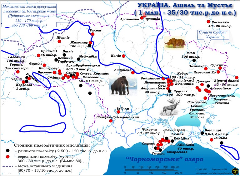
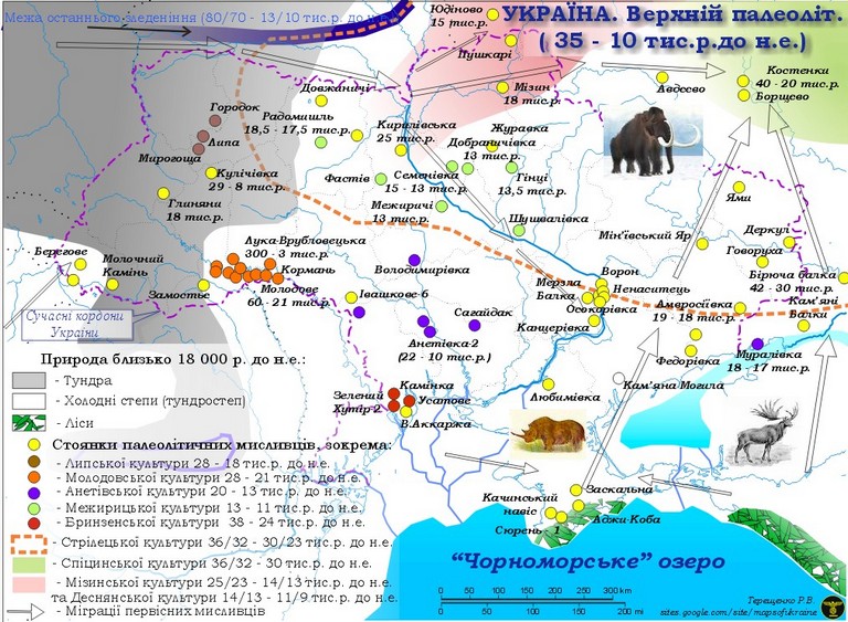
Уявіть Київ 20 тисяч років тому: суворий клімат, відкриті тундростепи та холодні вітри, що мчать з Півночі. Тут, серед безкрайніх рівнин, де сучасна цивілізація ще навіть не зародилася, жили перші мисливці на мамонтів. Кирилівська стоянка, знайдена на території сучасного Києва, відкриває унікальні сторінки історії людства та його боротьби за виживання в умовах останнього льодовикового періоду.

Як була відкрита Кирилівська стоянка?

У 1893 році чеський археолог Вікентій Хвойка, який на той момент уже жив в Києві та займався дослідженням давніх культур, працював на будівництві на Кирилівській вулиці (нині – район вулиці Фрунзе, тепер Кирилівська). Робітники копали ґрунт і натрапили на незвичайні кістки. Спершу їх прийняли за рештки сучасних тварин, але Хвойка, маючи досвід у таких питаннях, відразу зрозумів, що перед ним кістки мамонта.

Подальші розкопки виявили не лише останки великих тварин, а й численні знаряддя праці, виготовлені з кременю. Це стало доказом того, що місце було давнім поселенням людей. Хвойка припустив, що тут жили мисливці, які займалися загінним полюванням на мамонтів. Дослідження тривали кілька років, і кожен новий сезон приносив сенсаційні знахідки – наконечники списів, скребки, різьблені бивні, залишки жител.

Робота Хвойки була першою систематичною археологічною експедицією в Києві. Він детально описав усі знахідки, створив перші реконструкції способу життя давніх людей і довів, що Київщина була заселена ще в часи пізнього палеоліту.

Згодом, у ХХ столітті, дослідження Кирилівської стоянки продовжили радянські археологи. Використовуючи нові методи стратиграфії, вони уточнили вік поселення і довели, що воно існувало приблизно 20–15 тисяч років тому. Знахідки з цього місця зберігаються в музеях Києва, зокрема в Національному музеї історії України.

Археологічне відкриття

Стоянку виявили у 1893 році під час будівельних робіт. Археологи знайшли багатий шар крем’яних знарядь, рештки тварин та навіть мистецькі предмети, які доводять, що мисливці цього періоду не лише виживали, а й розвивали культуру.

Мистецтво та релігія: загадкові візерунки на бивнях мамонтів

Однією з найвражаючих знахідок Кирилівської стоянки стали різьблені бивні мамонтів. Вони містять складні геометричні візерунки – одні з найдавніших зразків мистецтва на території сучасної України. Вчені припускають, що ці орнаменти могли мати ритуальне або символічне значення, можливо, пов’язане з шаманськими обрядами чи спробами розповідати історії.

Знаряддя праці та зброя мисливців

Люди Кирилівської стоянки були вправними майстрами у створенні інструментів:

  • Крем’яні ножі та скребки використовували для обробки шкір і дерева.
  • Наконечники списів для полювання і війни.
  • Голки з кісток – ще один доказ того, що люди виготовляли одяг для захисту від холоду.

Що їли давні кияни?

Головною здобиччю мисливців були мамонти, північні олені та бізони. Віднайдені кістки вказують на те, що полювання було добре організованим: люди працювали в групах, використовуючи природні пастки та складні стратегії.

Давні житла: перші будівельники Києва

Рештки конструкцій вказують, що мешканці стоянки будували хижі, використовуючи:

  • Кістки мамонтів як основу каркасу.
  • Дерево та шкури для утеплення житла.
  • Вогнища всередині для обігріву та приготування їжі.

Ці будівлі дозволяли людям виживати в суворому кліматі, забезпечуючи захист від холоду та хижаків.

Аналогічні стоянки та межа льодовика

Кирилівська стоянка – не єдине місце, де знаходять сліди палеолітичних мисливців. Подібні поселення виявлені в Мезині (Чернігівщина), Межирічі (Черкащина) та Радомишлі. Вони мали схожі конструкції жител і спосіб життя.

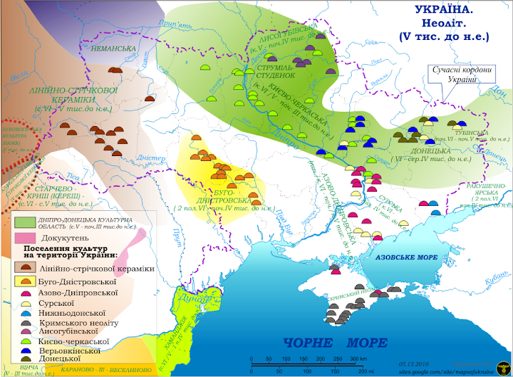
На момент існування Кирилівської стоянки льодовик уже відступив від Києва на північ, залишивши за собою валуни, озера і болотисті рівнини. Останні льодовики на території України танули близько 12 тисяч років тому, а 5 тисяч років тому клімат став теплішим, що сприяло появі трипільців та ямників.

Висновок

Кирилівська стоянка – це не лише археологічний об’єкт, а й унікальне свідчення про те, як наші предки змогли пристосуватися до екстремальних умов. Вона відкриває нам вікно в світ давніх мисливців, їхні традиції, мистецтво та технології, що заклали основу для розвитку людства на території сучасної України.

Дніпровське зледеніння

Дніпровське зледеніння: льодовик який сформував сучасний рельєф України

Що таке Дніпровське зледеніння?

Дніпровське зледеніння – це найбільше і найпівденніше зледеніння, яке охопило територію сучасної України. Воно відбулося приблизно 270–150 тисяч років тому в період Саальського (Рисського) льодовикового максимуму. Льодовик просунувся аж до лінії, що проходить через територію сучасного міста Дніпро, тобто приблизно на 500 км південніше Києва.

Це зледеніння змінило ландшафт, сформувало річкові системи та залишило після себе численні геологічні відклади.

Як льодовик змінив Київ і його околиці?

Київ знаходився на південній межі стійкого покриву льодовика, що вплинуло на його рельєф:

  • Формування пагорбів – льодовик приніс величезну кількість відкладів (морени), що створило нерівномірну височинну структуру, яку ми бачимо в Києві сьогодні.
  • Валуни льодовикового походження – у Київській області часто знаходять граніти, кварцити та гнейси, принесені льодовиком із території сучасних Скандинавії та Балтії.
  • Заплави Дніпра – під час танення льодовика утворилися великі потоки води, які розширили долину Дніпра та змінили його русло.
  • Піщані та глинисті відклади – після відступу льодовика Київщина отримала товсті шари лесових відкладів, що стали основою ґрунтів регіону.

Як льодовик вплинув на Дніпро та його долину?

Дніпро, як головна водна артерія України, зазнав кардинальних змін під час льодовикового періоду:

  • Розширення річкової долини – величезні об’єми води від танення льодовика розмили широкі русла, які сформували сучасний вигляд річки.
  • Льодовикові озера – після танення льодовика утворилися великі заплавні озера, залишки яких збереглися у вигляді сучасних заболочених низовин і стариць.
  • Підйом і спад рівня води – після завершення зледеніння рівень Дніпра зазнавав значних коливань через зміни клімату та поступове накопичення відкладів у руслі.

Звідки льодовик приніс каміння в Україну?

Дніпровське зледеніння принесло на територію України кам’яні відклади, походження яких можна простежити до таких регіонів:

  • Балтійський щит (Фінляндія, Швеція, Карелія, Естонія) – основне джерело кварцитів, гранітів та гнейсів.
  • Скандинавські гори (Норвегія, Швеція) – гнейси, амфіболіти та діабази, які зустрічаються у валунних відкладах Київщини та Полісся.
  • Південна Фінляндія та центральна Швеція – пегматити, апліти та інші магматичні породи, характерні для цих регіонів.
  • Естонія та Латвія – доломітові та вапнякові уламки, що інколи містять скам’янілості кембрійського та ордовицького періодів.

Геологи визначають походження цих порід за допомогою мінералогічного аналізу та порівняння з відомими зразками скандинавських та балтійських гірських порід.

Яке каміння залишило Дніпровське зледеніння?

Льодовик приніс на територію України породи, яких тут раніше не було:

  • Кварцити – міцна порода, що має характерний блиск і червонуватий або сірий колір.
  • Граніти – як місцеві, так і принесені з Балтійського щита.
  • Гнейси, амфіболіти – метаморфічні породи, що часто зустрічаються у валунах на Поліссі та в долині Дніпра.
  • Моренні відклади – суміш глини, піску, гальки та великих валунів.

Межа льодовика 5 тисяч років тому

Приблизно 5000 років тому, коли на території України мешкали ямники та трипільці, льодовиковий покрив уже відступив далеко на північ. Вплив зледеніння все ще був помітний у Поліссі, де існували великі заболочені ділянки, залишки колишніх льодовикових озер. Найпівденніші залишки льодовикових форм рельєфу в цей час можна було знайти у вигляді моренних пагорбів і валунних полів на півночі України.

Які тварини мешкали поруч із льодовиком?

Льодовикові рівнини та тундрові степи України в той час населяли:

  • Мамонти – основна мисливська здобич людей того часу.
  • Шерстисті носороги – пристосовані до холодного клімату, знаходили їжу у відкритих степах.
  • Бізони та дикі коні – паслися на просторах між льодовиком і степами.
  • Печерні ведмеді та леви – мешкали у більш теплих місцевостях, таких як печери Карпат.
  • Північні олені – мігрували великими стадами вздовж краю льодовика.

Як люди будували житла під час зледеніння?

Попри суворий клімат, люди все ж мешкали на території сучасної України. Археологічні знахідки показують, що:

  • Стоянка Мізин (Чернігівщина) – люди будували житла з кісток мамонтів та вкривали їх шкурами.
  • Кирилівська стоянка (Київ) – знаходиться неподалік Дніпра, містить сліди дерев’яних конструкцій.
  • Амвросіївська стоянка (Донбас) – показує адаптацію людей до суворих умов та використання печер.

Висновок

🧊 Льодовик давно зник, але його сліди залишилися в кожному пагорбі Києва та в розлогих просторах Дніпра!


Спадкоємність культур

Генетична історія населення України: від перших мисливців до Скіфії та античних міст до сьогодення

  1. Перші мешканці території України: мисливці на мамонтів і неолітичні культури Найдавніші відомі мешканці території України були представниками європейських мисливців-збирачів (Eastern European Hunter-Gatherers, EHG), які проживали тут ще в епоху пізнього палеоліту (~30 000 – 10 000 років тому).

Генетичні дослідження кісткових останків з Мізинської стоянки (~20 000 років до н.е.) показують, що ці мисливці мали гаплогрупу R1a та I2a, які пізніше зустрічаються у давніх землеробських культурах України (Mathieson et al., 2018). Вони поступово змішувалися з прибулими землеробами Близького Сходу (~7000 р. до н.е.), що сформувало неолітичні культури, зокрема Трипільську культуру. Генетичний аналіз трипільських поховань (Antonio et al., 2019) показав, що носії цієї культури мали гаплогрупи G2a та E1b, характерні для ранніх землеробів Анатолії, але поступово асимілювалися зі степовими племенами.

Цікаво, що на Мізинській стоянці були знайдені найдавніші з відомих археологам зображення свастичного знаку, меандру, виконані на кістці мамонта, першого викопного музичного інструменту(музичний браслет з кістки мамонту)

  1. Ямна культура та її вплив на Європу Близько 3300 р. до н.е. на території сучасної України поширилася Ямна культура, яка мала величезний вплив на Європу.

Дослідження (Haak et al., 2015) підтвердили, що Ямна культура була домінуючим джерелом R1b-M269 – гаплогрупи, яка сьогодні є найпоширенішою в Західній Європі. Ямники також мали змішане походження, включаючи місцевих мисливців-збирачів та неолітичних землеробів. Саме вони стали основними предками індоєвропейських народів, які пізніше розселилися по всій Євразії.

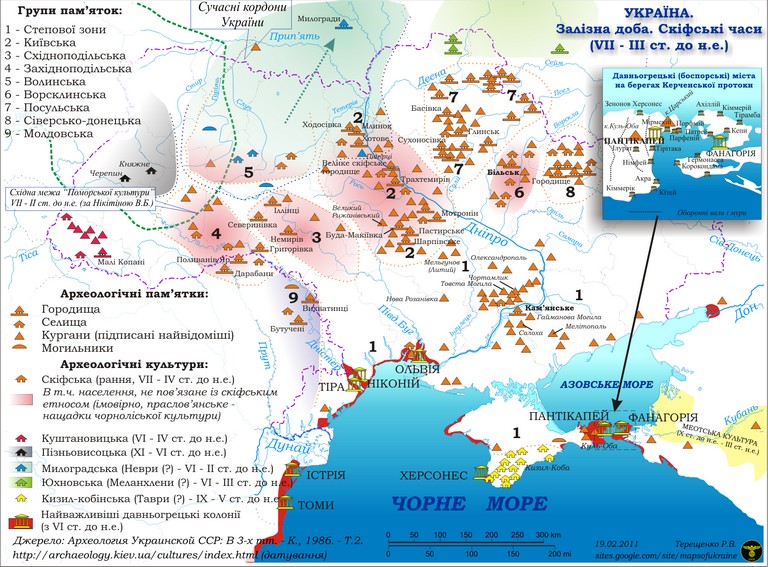
  1. Скіфи: чи були вони автохтонними нащадками ямників? Генетичні дослідження скіфських поховань (Krzewińska et al., 2018; Unterländer et al., 2017) показали, що:

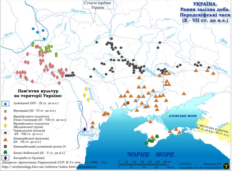
Скіфи були генетично різнорідною групою, сформованою під впливом як ямників, так і азійських степових народів. Основні гаплогрупи: R1a-Z93 (індоарійське походження), Q1a (центральноазійський вплив), C2 (монголоїдна складова у частини пізніх скіфів). Аналіз мітохондріальної ДНК (жіночої лінії) показав, що скіфи мали тісний зв’язок із населенням бронзового віку України, але також містили гени, характерні для кочовиків Алтаю та Центральної Азії. Це підтверджує теорію, що скіфи сформувалися з місцевого населення степової зони (нащадків Ямної культури), але зазнали впливу міграцій із Сходу.

  1. Античні грецькі колонії та їхній генетичний вплив У VIII–V ст. до н.е. на узбережжі Чорного моря виникли грецькі колонії (Ольвія, Херсонес, Тіра, Пантікапей).

Аналіз поховань у грецьких некрополях (Damgaard et al., 2018) показав наявність середземноморських гаплогруп (J2, E1b, G2), характерних для Греції та Анатолії. Проте місцеве населення (скіфи та фракійці) також залишило свій генетичний внесок, що призвело до утворення змішаних елліно-скіфських груп. Це підтверджується антропологічними дослідженнями: у грецьких колоніях часто зустрічаються антропологічні риси як європеоїдного середземноморського типу, так і північного (скіфського) типу. Отже, греки залишили генетичний слід на півдні України, але в меншій мірі вплинули на генетичний склад центральних і північних регіонів.

  1. Курганні культури Багато давніх культур, що існували на території України, належать до курганної традиції поховань. Найвідоміші з них – Ямна культура, культура шнурової кераміки та культура кулястих амфор.Характерною рисою всіх цих культур був поховальний обряд: покійників ховали у прямокутних ямах, у давнину посипаючи їх червоною вохрою. Пізніше цей обряд трансформувався у сучасну традицію прикрашати домовини червоними гвоздиками. Кургани насипалися над могилами всіх соціальних станів, а для вождів і царів вони були особливо великими.
  2. Кримські татари: Генетичні дослідження кримських татар (Kushniarevich et al., 2015) показують, що вони є нащадками різних етнічних груп, які населяли Крим у давнину, включаючи таврів, скіфів, сарматів, половців та огузів. Їхній генофонд містить як степові, так і середземноморські компоненти, відображаючи складну історію регіону.
  3. Караїми та кримчаки: окремі етнічні групи Криму Генетичні дослідження показують, що караїми мають спорідненість з євреями, але з домішками місцевого населення Криму. Кримчаки – це окрема група євреїв, які сформувалися в Криму, поєднуючи семітське та місцеве європейське коріння.
  4. Вірмени та євреї-ашкеназі: нові хвилі переселенців Вірмени з’явилися в Україні ще в Київській Русі та особливо в середньовіччі, залишивши значний слід у культурі та генетиці.
  5. Ашкеназі-євреї переселялися в Україну після вигнання з Центральної Європи, хоча легенди пов’язують їхнє перше прибуття ще з часів скіфських походів на Близький Схід.

Why it is not worth restoring the Kakhovka Hydroelectric Power Station?

I join the discussion regarding the need to restore the Kakhovka Reservoir. Here are the arguments against its restoration:

  1. Logistics: To connect the right and left banks of the Dnieper River, bridges are needed, not the restoration of the reservoir. Instead, new bridges can be built over the natural riverbed, which is not possible if the reservoir is restored.
  2. Desertification: With an annual precipitation of about 400 mm, a desert will not form. The area of the former reservoir will initially be overgrown with weeds. It would be better for people to assist this process by seeding or planting vegetation on these lands, for example, using drones. In the future, part of these lands could be used for growing energy willows, considering the proximity of groundwater.
  3. Water supply: Kryvyi Rih is already restoring its water supply by utilizing water from the Kremenchuk Reservoir, which comes through the Inhulets River. A water pipeline is being built from Zaporizhzhia to Manganese, Nikopol, and Pokrov. The cooling pond of the Zaporizhzhia Nuclear Power Plant is located on the banks of the natural riverbed of the Dnieper, so supplying water there is not difficult. Diversification of water supply is an important measure to counter terrorist threats.
  4. Decreased water volume: Without the Kakhovka Reservoir, the amount of water in the Dnieper will not decrease. From the Kakhovka Reservoir, the average annual evaporation losses amounted to 1.81 cubic kilometers, which means that the annual flow of the Dnieper would increase by this volume of water. Seasonal fluctuations in river flow are regulated by the five Dnieper reservoirs. During low-water periods, they are intended to release water downstream.
  5. Irrigation: The challenge lies in raising water from the natural riverbed of the Dnieper to a height of about 10-20 meters to match the elevation of existing canals and aqueducts (including the North Crimean Canal). Modern pumping systems and a network of small hydraulic structures (ponds) could be developed. Solar power stations on the former reservoir lands can generate the necessary electricity. Irrigation canals in the steppe led to soil bogging and secondary salinization. Modern irrigation technologies, such as drip irrigation, require less water and enable the development of intensive farming (vegetable production), which is more profitable than growing grain crops.
  6. The emergence of 2,000 km² of land that can be beneficial. This land can be used for construction, solar power plant installations, cultivation of specific crops, restoration of natural landscapes, and more. The conditions for manganese ore mining in the Nikopol Basin have improved.
  7. Possibility of restoring (reconstructing) sacred places for Ukrainians – elements of the Great Meadow and the Sich: Tomakivska, Bazavlutska, Mykytynska, Chortomlynska, Nova Sich (Pidpilnentska). Archaeological research of this territory is starting.
  8. Improvement of Dnieper water quality due to the absence of stagnation, marsh formation, and algal blooms. The restoration of natural spawning grounds for valuable fish species (sturgeons) becomes possible.
  1. Avoiding the danger of dam destruction: People who experienced the tragedy caused by the destruction of the Kakhovka Hydroelectric Power Plant dam would unlikely want to be exposed to such a threat again, which would occur if the reservoir is restored.
  2. Restoration of navigation on the Dnieper can be achieved through dredging, construction of locks, or, as a last resort, bypass canals. Most of the rapids were flooded by the Dnieper Reservoir. It is necessary to study the experience of EU countries where similar rivers are navigable without the creation of reservoirs.
  3. For those who advocate for the restoration of the dam, I propose considering the option of constructing dams along the Dnieper that would allow raising water levels without flooding lands. Let Ukrhydroenergo include this in their budget. Its director, Ihor Syrota, mentioned that restoring the Kakhovka Hydroelectric Power Plant would require $1 billion and 5 years, so perhaps this amount could be used for building protective dams. Additionally, there are run-of-the-river hydroelectric power plants that do not require the construction of dams. Unfortunately, small hydropower plants, which devastate our rivers, are classified under the “green” tariff, allowing them to profit significantly at the expense of our pockets. As of early 2022, the share of hydropower and pumped storage power plants in Ukraine’s electricity production structure was only 6.7%. I hope for wise decisions by Ukrainians who will be guided by modern approaches to environmental management and not restore “Soviet monsters.” In the USA and the EU, thousands of dams have already been dismantled, and they have significant positive experience with reservoir decommissioning (dams removed in the USA: https://www.americanrivers.org/dams/database/; dams removed in the EU: https://damremoval.eu/dam-removal-map-europe/). Our task as scientists is to explore all aspects and experiences of leading countries, engage in discussions, and provide explanations. I thank our defenders for the opportunity to live and work. My condolences go to all who have suffered from the war. Glory to Ukraine!
  4. Olga Helevera

PREVIOUS ENVIRONMENTAL AND ECONOMICAL RESULTS OF DNIPRO RIVER ECOSYSTEM TRANSITION TOWARDS SUSTAINABLE FUNCTIONING

The analysis of Dnipro river ecosystem condition has been performed in historical and modern aspects following basic reasons for water reservoirs cascade creation. The environ- mental and economical analysis of water dams functioning is presented. The forecast variants of Dnipro river ecosystem transition towards sustainable functioning by dams decommission- ing are shown as well.

Dnipro Today: Only Groaning, No Roaring Anymore. On the Feasibility of Reservoir Discharge Project and Restoring the Ecosystem of Ukraine’s Main Water Artery to its Natural State.

The problem addressed in this article is crucial not only for us but also for future generations because the functioning of the Dnipro River ecosystem significantly influences the environmental conditions and livelihoods throughout the territory of Ukraine, from its northern to southern borders.

Theoretically, all development scenarios for the Dnipro River basin can be divided into two groups. The first group consists of scenarios that prioritize the natural and most comfortable state of the Dnipro River for humans. This state requires minimal maintenance costs, ensures the preservation of natural resources, land, vegetation, soil, forests, biodiversity, and satisfies the population’s needs for recreation and tourism. Natural ecosystems have unique abilities for self-regeneration and self-restoration. The second group of scenarios is based on the opportunities provided by cascade reservoirs, the majority of which require reconstruction, involving significant financial and resource investments. The operation of such facilities alters the surrounding environment, leading to negative consequences for humans and the environment. Additionally, it requires additional measures and resources for purification, reinforcement, and other purposes.

So, what kind of nature do we need – a temple or a workshop, figuratively speaking? This question is now posed to us with renewed relevance.

“The wide Dnipro roars and groans” – the poetic line by Taras Shevchenko vividly depicts the mighty Slavutych. Renowned historian Dmytro Yavornytsky summarizes the natural potential of this water artery as follows: “Dnipro, mighty, wide, full-flowing, rich in fish, with its luxurious green valleys, impassable floodplains, teeming with birds, animals, and forests.” References to this colossal, rich, and enchanting river can be found in sources dating back to ancient times, including the works of the ancient Greek historian Herodotus (450 BCE): “The Borysthenes (Dnipro), among the Scythian rivers, is the largest and, in our opinion, the most abundant in nourishing products, not only compared to the Scythian rivers but to all rivers in general, except for the Egyptian Nile.”

Detailed descriptions of the Dnipro, including its rapids, can be found in the works of the Byzantine Emperor Constantine VII Porphyrogennetos at the end of the first millennium CE. A bit later (1630-1648), French military engineer G.L. de-Boplan, while serving the Polish king and leading the construction of fortifications in southern Ukraine, paid special attention to the Dnipro rapids in his work “Description of Ukraine.” For example, when exploring the Samara River, a tributary of the Dnipro, he noted the following phenomenon: during fish spawning, a sunken stake in the water maintained a vertical position, indicating the dense schools of fish. Even until the 1930s, the Dnipro satisfied the population’s demand for fish, ranging from bream to herring and sturgeon. The grandeur of the Dnipro rapids (waterfalls, picturesque silhouettes, and thundering waters) fascinated travelers. The Scythians and Alans adored the rapids and worshipped this natural wonder. And rightfully so, as within a nearly 70 km stretch, the river created nine picturesque rapids and over 30 shallows. (According to Dmytro Yavornytsky: “Rapids are a ridge of stones that span the river from one bank to another, and shallows are a ridge of stones that only partially obstruct the river, allowing free passage from one side of the river.”) At the same time, they posed a significant obstacle on the waterway, making it nearly impossible to overcome without the assistance of experienced pilots.

Until the 19th century, the ecosystem of the Dnieper River was primarily viewed in terms of its terrestrial-aquatic productivity and transportation capabilities. Due to the rapid development of the economy in southern Russia, the transportation component gained increasing importance, as there was no cheap and extensive road network. Therefore, in imperial Russia, all issues related to such an important transportation artery as the Dnieper River were addressed by the Ministry of Communications. Both hydrography and climate, forest cover, the amount of precipitation, ice conditions, water quality, and even environmental preservation issues, forest and swamp protection throughout the Dnieper basin were important subjects for research and management within this ministry. Essentially, it was a well-coordinated system of comprehensive monitoring of the entire Dnieper River basin, based on which all decisions were made by one ministry, which we still do not have today. All of this is well documented in two fundamental works by transportation engineer M. Maksimovich. It is worth noting that none of the navigation improvement projects included flooding the rapids; they were based solely on widening narrow passages, constructing bypass canals, or installing locks.

During the Soviet era, the attitude towards nature underwent radical changes. Nature was seen as a workshop, not a sanctuary, and humans were its masters. This led to massive transformations in the environment, including the ecosystem of the Dnieper River. In 1927, a decision was made to construct the Dnipro Hydroelectric Power Station (HES), for which the Dnieper Reservoir was created between Zaporizhia and Dniprodzerzhynsk, with a total area of 30,000 hectares and a dam height of 37 meters. The main motivations for this construction were to provide passage for ships without the need for transshipment, obtain cheap electricity, and significantly increase the area of irrigated land.

The planned results were achieved within a short timeframe, and they were even used as evidence of the advantages of the socialist system, although similar approaches to river exploitation were known worldwide. However, no one considered the negative consequences. This included the loss of natural treasures like the Dnieper rapids and unexplored historical sites from the Scythian-Alan-Cossack period. It was not taken into account that the sedimentation of the reservoir would eventually transform the river into a lake-marsh type water body, despite the knowledge of the complete sedimentation of the Hindukush Reservoir in just 13 years (and the Kur River reservoir being more than 60% silted). It was ignored that the planned flooding would create numerous shallow areas with subsequent water blooms, and the regulation of the river and changes in water levels for hydropower needs would lead to the destruction of certain fish species and a decrease in their catch. The global trends in transportation development were also disregarded.

Based on such reasoning, the implementation of the Dnipro Hydroelectric Power Plant (HPP) project began, and by 1931, two lower thresholds were flooded, and by 1934-1935, the reservoir was almost formed. Interestingly, in 1927, the Dnipropetrovsk Hydrobiological Station was established for the study of the Dnipro River’s water area in the flooding zone. Here are some results of its research: the appearance of blue-green algae was observed in shallow areas, and the river’s flow velocity significantly decreased. In 1929, the flow velocity of the Dnipro River near Dnipropetrovsk was 0.63-0.83 m/s, and near the Vilyi rapids, it was 1.27-4.7 m/s. After the flooding, it decreased to 0.03-0.88 m/s and 0.01-0.19 m/s, respectively. The water transparency after the Vilyi rapids increased from 0.80 cm to 200 cm. Within three years, the thickness of the sediment layer doubled, clearly indicating a lake-type reservoir. The chemical composition of the water deteriorated significantly due to industrial production growth and the regulation of discharge.

Despite this, during the post-war period (1950-1975), five more reservoirs were created, and the Dnipro River became completely regulated throughout Ukraine. Thus, the “grand” plan to rebuild the ecosystem of the Dnipro River was completed. What did we get as a result?

First of all, there was the possibility of transporting passengers and goods without transshipment. However, the dynamics of these indicators show a constant decrease in the share of water transport in the overall volume of transportation.

The construction of hydroelectric power plants allegedly allowed obtaining cheap and environmentally clean electricity. Indeed, if we disregard the fact of destroying coastal ecosystems, it is relatively clean. The share of electricity generated by the Dnipro cascade of HPPs accounts for 5-7% of the total electricity produced in Ukraine. As a result, maintaining the Dnipro cascade of HPPs costs the country 6-30 times more than the value of the energy produced by them. So, our hydropower is not as cheap as it seems!

The expected increase in fish catch with the creation of reservoir cascades did not occur. The sharp increase in catch during the early years of reservoir creation (up to 100,000 tons in 1973) quickly declined, and by 1991, it was around 30,000 tons, a level that persists to this day. In the Dnipro River, many species of typical river fish disappeared, including beluga, sturgeon, Black Sea-Azov sturgeon, salmon, river conger, and the population of sterlet, vimba, asp, tench, bleak, and roach dramatically decreased. They were replaced by lake forms such as bream (which accounts for about 40% of the catch), pike, catfish, carp (the domestic form of common carp introduced from fish farms), roach, and perch. In recent years, the development of populations of “immigrants” such as grass carp and white amur, which require artificial fingerling rearing, has been gaining momentum.

All of this is a result of water blooming, destruction of natural spawning grounds, the inability to overcome dams during migration to spawning grounds, the loss of fish and fingerlings in hydropower units, water level fluctuations (within a day), water pollution, and the inefficiency of artificial fish breeding.

Blue-green algae are becoming increasingly widespread, with the maximum amount observed in the Dnipro reservoirs in July-August. The thickness of the surface layer of algae ranges from a few millimeters to 15 cm. The seasonal “attack” of blue-green algae is devastating to the biota.

In the upper reaches of the reservoirs, the flow velocity sharply decreases, accumulation zones form, and so-called internal deltas are formed. In the Kremenchuk Reservoir, dozens of hectares of such secondary islands have already emerged from under the water. Similar phantom islands appear in Lake Lenin during the lowering of the water level by the Dnipro HPP.

The creation of the cascade of the Dnieper reservoirs has intensified destructive exogenous processes, leading to the destruction of coastal ecosystems, forest vegetation, chernozem soils, buildings, structures, roads, and communications, and continues to have a negative impact. Shoreline abrasion has led to the disappearance of lands in the coastal zone of the Kyiv reservoir with a width of up to 450 meters.

One of the most acute regional environmental problems has been the loss of small rivers. The majority of them belong to the Dnieper River basin and are all influenced by the cascade of the Dnieper reservoirs. The Dnieper River basin includes 20.5 thousand very small, small, medium, and large rivers with a total length of over 105 thousand kilometers. Small rivers account for 60% of Ukraine’s water resources. Most of the small rivers in the Dnieper basin have an ecological state classified as either catastrophic or poor.

An important direction for the use of reservoirs is to ensure water supply stability and provide water to low-water areas of the Donbas and Crimea. One of the arguments in favor of creating the Dnipro­dzerzhynsk hydropower plant was the need to build the “Dnipro-Donbas” canal to supply water to low-water areas of the Donbas and redirect part of the Dnieper River flow to the Siversky Donets River. However, since its creation, the canal has been used at a maximum of 30%, and in 2000, only 8%. This canal was only extended to the Oril reservoir in the Kharkiv region, and the second stage, reaching the Donbas, was never built.

The Donbas has found itself in a paradoxical situation: there is nowhere to discharge mine waters, and at the same time, there is a water shortage for consumption. A similar situation exists in Crimea. It is evident today that the entire water supply system of Crimea requires reconstruction, particularly the North Crimean Canal.

Water losses during transportation due to filtration losses have been rapidly increasing (from 23% to 52% between 1998 and 2003). These significant percentages have a negative impact on the ecological state of the territory, leading to flooding and land degradation.

In general, the operation of the canal does not require the Kakhovka reservoir. Modern equipment provides the technical capability to lift water to the initial canal structures from the primary water level of the Dnieper River.

Thus, the conclusion that the technical and resource capability exists to meet modern water consumption needs without reservoirs is essentially justified.

The creation of the cascade of reservoirs on the Dnieper allowed for the implementation of a large number of irrigated lands. However, high water consumption and an imperfect drainage system have led to the flooding of many settlements, with the flooded area of agricultural land amounting to 90 thousand hectares. About half of the irrigated lands are in an unsatisfactory or satisfactory condition with a threat of worsening eco-meliorative state. The need for the application of new irrigation technologies (such as drip irrigation) or soil conservation measures, which involve significant reductions in water consumption, becomes increasingly evident.

In this regard, it is interesting to compare the positive results and negative consequences of creating the cascade of reservoirs. Statistical and official data were used for their assessment, and in some cases, expert evaluation was applied. The presented table leads to a very unexpected conclusion: the operation of the reservoir cascade is not only not beneficial but economically unprofitable. Moreover, the negative consequences outweigh the positive results two to nine times.

Currently, there are national and regional programs in Ukraine aimed at improving the health of the Dnieper River. However, all of them focus on improving water quality, without addressing the fundamental solution of restoring the natural functioning of the Dnieper River. Meanwhile, suggestions to eliminate the reservoirs have been proposed multiple times, but such proposals have not been accepted by the government or society. Why?

  1. First of all, such proposals were based on one or several facts of negative impact, without conducting comprehensive assessments.
  2. The second reason is the unwillingness to take responsibility, as the consequences of reservoir draining will be extensive, and changes in management will require significant investments. However, if all the expenses for maintaining reservoirs and hydropower plants are eliminated and the finances are concentrated, they would be sufficient to adapt the management to new environmental conditions.
  3. The third reason is a limited understanding of the processes that will occur in the sediment during its drying after reservoir draining, as well as concerns raised by some scientists that the consequences could be similar to the Chernobyl accident. There have been no specific studies conducted, but there is compelling evidence from the period of 1941-1945, after the explosion of the Dnipro Hydroelectric Station dam. There were no dust storms then, and the exposed banks were initially covered with grassy vegetation, followed by shrubs and trees. Furthermore, the water release can be gradual, with predetermined stages for each reservoir.

The technical and economic justification of the “Rehabilitation of the ecological state of the Dnipro River within the city of Dnipro under the National Program for the improvement of the Dnipro Basin and drinking water quality,” carried out in 2009 by the design and research institute “Dniprodiprovodhosp,” confirms the feasibility and effectiveness of at least partially restoring the Dnipro River to its natural state. In order to assess the predicted results of reservoir draining, we conducted a preliminary economic analysis of the consequences of draining the Kakhovka Reservoir. The obtained data indicate that the positive consequences of reservoir draining outweigh the negative ones at least five times. Of course, the balance of positive and negative effects will vary for other reservoirs, but the overall trend will remain.

In conclusion, let’s summarize the presented information.

The existence of a cascade of reservoirs on the Dnipro River leads to significant economic costs for maintaining their operation, which increase every year. The negative consequences of the reservoirs’ impact on coastal and aquatic ecosystems are also growing.

The Dnipro reservoirs have caused a range of negative phenomena described above, such as land flooding, degradation of small rivers, shore erosion, submerging of unique natural objects like Dnipro rapids, deterioration of water quality, and the catastrophic development of blue-green algae, among others.

Preliminary calculations indicate that the removal of dams will lead to the sustainable functioning of the river ecosystem, enabling clean water supply for the population, obtaining additional land for agricultural use, improving the efficiency of fisheries, and restoring floodplain ecosystems, among others. Economic analysis shows that the losses from reservoir utilization significantly outweigh the benefits.

Попередній прогноз змін від демонтажу Каховського водосховища свідчить, що позитивні нас­лідки переважають негативні принаймні вп’ятеро.

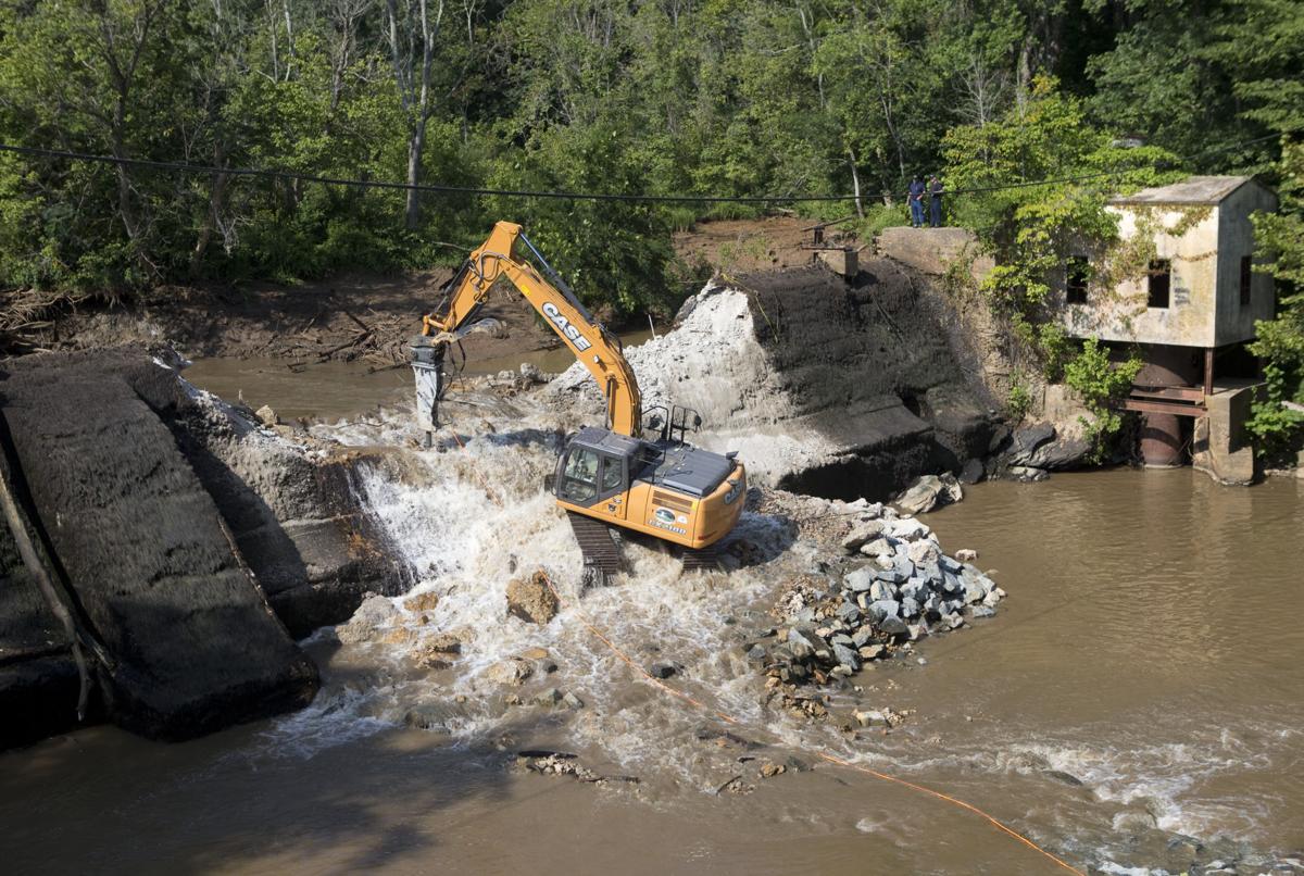
World experience shows that the general direction for addressing basin ecological problems lies in discontinuing dam construction and dismantling reservoirs. In the United States alone, 350 dams have been dismantled over the past decade.

Management of consumption and restoration of ecosystem resources in the Dnipro River should be based on a basin principle. The functions of the Dnipro River Basin Council should be more effectively utilized and empowered to develop proposals for the development of the country’s main water artery and the exploitation of its resources.

The sooner we realize the need to restore the ecosystem of the Dnipro River to its natural state, the more reliably we will provide conditions for current and future generations to build sustainable development.

Arkadiy SHAPAR.

Roaring and Groaning: Demolition of Hydropower Plants on the Dnipro River

The mighty Dnieper roars and bellows,
The wind in anger howls and raves,
Down to the ground it bends the willows,
And mountain-high lifts up the waves.
Reading these lines in literature textbooks, any Ukrainian student can be surprised; the described Dnipro by Kobzar is not encountered today. However, the reason for this is banal; most often, when you arrive at the banks of the Dnipro, you don’t see a river, from the middle of which only a rare bird can be heard, but rather a lake.The cascade of hydroelectric power plants on the Dnipro River (I can’t bring myself to write “na richci”) was built in the 1930s-1970s. Its construction can be divided into two stages: before the 1950s and later. The first stage of utilizing the energy of the water of the Slavutych started long before the launch of the Dnipro Hydroelectric Power Plant, the meetings of Khrushchev in the Kherson steppes, and so on. The idea of using the Dnipro as a source of electricity was proposed by scientists during the time of the Russian Empire, and their ideas were focused on only one place where this energy was demonstrated in the most vibrant way, even touching the soul of Kobzar…

The Dnipro Rapids.

The rapids on the Dnipro River formed simultaneously with the formation of the river itself, in a form known to us, during one of the stages of the ice ages. The water, from the melting of millennium-old ice and intense precipitation in the Valdai Upland, sought its way south and found it (in Belarus, the Dnipro has a meridional direction; simply from north to south) until it encountered a highland known today as the Prydniprovian Upland, which hindered its flow.

The place where the mountains hindered the water is known to you as the city of Kyiv; the Dnipro Rapids are the edge of the upland, eroded thousands of years ago. From Kyiv, the Dnipro River gradually changed its course to the southeast; the waters flowed along the upland until they found a weak spot in it. There, the Dnipro formed a canyon within the cliffs of the Prydniprovian Upland.

The village of Vovnigy, before it was flooded. Now, on the banks of the Dnipro Reservoir, there exists its “new version.”

In this canyon, the Dnipro had the highest gradient along its entire course from Valdai to Ochakiv; over the 60-70 kilometers that separated Katerynoslav and Oleksandrivsk (Dnipro and Zaporizhzhia), the water descended almost 30 meters. For a lowland river like the Dnipro, this is a significant gradient.

But the upland did not give in without a fight; rocky outcrops of mountainous rocks across the path of the water became rapids. The Dnipro Rapids.

Despite the beauty of the struggle between the two elements – land and water – overcoming the river rapids has always been a challenging task for river transportation. Nowadays, we would call it “rafting,” but engaging in rafting when you need to transport furs and honey from Kyiv to Tsargrad (Constantinople) on a ship with a tonnage of a hundred tons is not just a refined pleasure; it is pure torment on the nerves.

In addition to the rapids, there were also weirs – rocky outcrops that didn’t span the entire width of the river but only a specific section, leaving a passage for water somewhere in the channel. Weirs posed a challenging task for pilots as the water current speed sharply increased around them.

The transportation problem posed by the rapids played a significant role in Ukrainian history, and it is no wonder that the Cossacks, who gained their freedom in navigating through them, are called Zaporozhians.

By the end of the 19th century, the rapids had become a major annoyance for the imperial government. The large-tonnage steamships of that time, unlike the Cossack boats, faced great challenges in navigating through the rapids. Essentially, due to the increasing size of river vessels, the Dnieper River became impassable for shipping. Initially, proposals were made to cut a canal through the rapids or parallel to the Dnieper’s course. It should be noted that the excavation of the rocky formations of the Pridneprovskaya Upland along a distance of 60 kilometers would have been comparable to the construction of the Panama Canal. It would have been a monumental engineering task. However, at the beginning of the 20th century, specialists from a different field intervened. They were engineers specializing in hydropower.

That marked the end of the first stage of hydropower development on the Dnieper. The second stage began. You know, in a way, I can even agree with the Soviets. “Nature is a workshop” is a slogan that sounds scary, but its essence is universal. The thing is, irrational beings, not surprisingly, do not have an impact on the nature around them; they are part of it. Humans, as rational beings, have different characteristics of existence – they need to dress warmly, cook food over fire, and illuminate themselves with electric lamps. All of this is due to the demands of their intelligence, or rather, their understanding of their needs. Intelligence allows them to understand that running around naked and freezing is not very rational.

Perhaps it is no coincidence that the Jews declared it the “original sin” in their national bestseller, to bite from the tree of knowledge against the will of God. Therefore, humans understand their needs. Fortunately, they can, using their intelligence, satisfy them in the least harmful way for nature. Instead of fur coats (remember, animals are killed for fur), there are synthetic fiber suits. Instead of open fires and oxygen depletion, there are induction stoves.

Those who decided to build five more hydroelectric power stations on the Dnieper clearly only used their intelligence to realize their needs, and poorly at that…

In 1955, the next one, the Kakhovka Hydroelectric Power Plant, was built. Its main purpose was to supply water to the North Crimean Canal. Then, as if from a horn of plenty, the Kremenchuk, Seredniodniprovsk, Kyiv, and Kaniv Hydroelectric Power Plants were built in 1959, 1963, 1964, and 1972, respectively.

The Dnieper turned into six reservoirs, two of which – the Kakhovka and Seredniodniprovsk reservoirs – supplied water to the Dnieper water for the canals in Crimea and the Donbas. Slavuta transformed from a turbulent river into a “cascade of hydroelectric power plants.” These are not just empty words.

Out of over a thousand kilometers of the Dnieper’s flow in Ukraine, only a little less than two hundred remained in their natural state – near Kaniv and downstream from Kakhovka. The flow rate has decreased by an order of magnitude – the self-purification of the Dnieper from all that Ukraine discharges into it has become almost impossible.

Reservoirs flooded about 7,000 square kilometers of land, a small portion of which was used for agriculture. Hundreds of villages and towns were submerged, and the largest city – Novohrodivka – found itself at the bottom of the Kremenchuk Reservoir.

The most voluminous reservoir, the Kakhovka Reservoir, has covered a unique steppe nature reserve called Velikiy Lug. The “father” of the Cossacks, the jungles in the middle of the steppe, could hide a million-strong army; they hid, even though they had smaller forces – it was here that 7 out of 9 Zaporizhian Sichs were located.

It seems that the Soviet government did not need the Cossacks in any sense.

Initially, the reservoirs demonstrated a colossal increase in fish catch – up to 100,000 tons in the 1970s. However, currently, fishing on the Dnieper River does not yield more than 20,000 tons, mainly due to water bloom and pollution from all over the country (consider the self-purification and flow rate). The quality of fish is questionable.

The majority of the reservoir areas, proudly referred to as “seas” by Soviet hydroengineers, are shallow (for example, one-third of the Kiev “sea” has depths of up to 2 meters). The shallow areas heat up well in the summer, and due to the stagnant water and organic pollution, they begin to “bloom.”

One might think that all of this could have been exchanged for electricity. However, if you look into the capacity of the hydroelectric power stations (HPPs) on the Dnieper, you can’t help but think, “What the hell, electricity…”

The most powerful HPP on the Dnieper, both currently and throughout the entire existence of the HPP cascade, is the first one in Zaporizhia. DniproHES has an installed capacity of 1,570 MW (equivalent to two industrial nuclear reactors, my goodness!) with a water head of 38 meters. The reservoir area is close to 400 km², which, by the way, is the smallest in the cascade. The reason for this is the Dnieper Canyon through the Prydniprovska Upland – the flooding did not spread “wide,” but only covered the natural “bed” of the river. Information regarding the rest of the reservoirs is provided in the table below.

HPP Name Installed Capacity Reservoir Area Water Head
Kakhovka 351 MW 2,155 km² 16.5 m
Kremenchuk 633 MW 2,252 km² 14.2 m
Serednio-Dniprovska 352 MW 567 km² 10.2 m
Kyivska 409 MW 922 km² 12 m
Kanivska 444 MW 675 km² 7.5 m

None of the power stations even reach half the capacity of DniproHES. As for the “weakest” of them, the Serednio-Dniprovska HPP, I’ve heard that it only “maintains the frequency” in the power grid and serves as an auxiliary source of generation. To illustrate how poorly utilized these 7,000 km² are, let me mention one fact.

The area of the Three Gorges Dam reservoir in China suddenly amounts to only 1,045 km². It is a significant figure for a hydropower plant built in the mountains, but the power of the Chinese hydroelectric complex outweighs these losses – 22,500 MW. That’s equivalent to 25 industrial nuclear reactors. The largest HPP in the world.

Moreover, due to problems caused by the HPP cascade, a portion of this electricity has to be used for the needs of the cascade itself. For example, the Bazavluk River, which used to flow into the Dnieper in the area of the Great Lug, has to be literally “pumped” by pumps into the Kakhovka Reservoir due to the difference in water levels. The rise in water level has also caused other troubles, such as increased groundwater levels. Soils are inundated along the entire cascade, and even rumors about it have reached places like Bozhedarivka (formerly Shchors), tens of kilometers away from the Serednio-Dniprovska HPP reservoir. I don’t know if those rumors can be trusted, but still…

This is the price that always has to be paid for the construction of hydropower plants in plain areas. The world has long abandoned such construction because buying out lands from owners who are against their three hectares being submerged is too costly, and the low-head HPPs have too little power for economic efficiency (what kind of head can you create in the middle of the steppe?). It is more profitable to invest in HPPs in high mountain areas, and mountainous countries continue to build HPPs even today (Norway, a narrow strip of land between the northern slope of the Scandinavian Mountains and 100,500 fjords, receives over 70% of its electricity from HPPs). But as for plain countries like Ukraine, they avoid building “seas” due to the laws of economics. However, what can you do when your country’s “laws of economics” have been unique for 70 years in a row?…

Well, no, the laws of economics have been universal here for the past 28 years. The question remains, what should be done? =)

Well, the title of this post leaves no room for alternative solutions to the cascade of hydropower plants (HPPs) problem. The construction of five HPPs in the plains was a mistake caused by a lack of intelligence and a desire to show off “engineering skills” in the surrounding environment. All the power generated by the cascade, except for DniproHPP, could easily be replaced by a single large thermal power plant or two to three nuclear power plant units. Moreover, if solar panels or wind turbines were installed on one-third of the land freed up by draining the water, the energy produced by them would be more than enough to compensate for the losses from dismantling the HPPs.

The idea of such dismantling is not new: my article is based on numerous sources, from popular articles to scientific papers. As early as 1991, Oles Honchar spoke from the rostrum of the Verkhovna Rada, saying, “It is believed that on the site of these decaying nuclear seas, the bread of the people’s wealth, prosperity, gardens, gardens of independence and freedom will shine.” In fact, the mention of these words in Leonid Kuchma’s book “Ukraine is not Russia” inspired me four years ago to search for information on this topic, and information was found.

The practices of other countries show that plain HPPs, like the second stage stations of the Dnipro hydrosystem, are often dismantled in our time, both in European countries and within the former leader of large HPP construction, the USA. By 2008, about 450 dams had been dismantled, 28 of which were large HPPs with a head over 15 meters (au, Kaniv HPP, why were you even built?). Moreover, hydroelectric power plants in the Rocky Mountains are also being dismantled, where the area of flooded land is minimal. The rationale? Ensuring fish passage. It may seem funny to us, but not to Americans, as they enjoy salmon.

One could argue that restoring the ecosystem in the “Ukrainian Atlantis” territories would require a lot of money and time. However, there is a counterexample: the “dismantling” of DniproHPP in 1941 and 1943. Both times, the banks of the Dnipro quickly overgrown with grass and bushes without any human intervention (there was a war going on, they had other priorities). After the second destruction of DniproHPP, it was restored only in the early 1950s, and the banks of the Dnipro remained exposed for years. There were no dust storms like in the dried-up Aral Sea today. Not to mention that the lowering of the reservoirs of HPPs will be slow and gradual, not in a “we blew up the dam!” manner.

In the sources I mentioned and others that can be found on the internet, various options for the reconstruction and/or dismantling of the cascade are proposed: from the reconstruction of all HPPs with a reduction in the head level to the complete dismantling of all HPPs. I (although I am far from hydropower engineering) would recommend preserving DniproHPP while completely dismantling the other five HPPs.

After all, it is the most powerful HPP in the country with the smallest reservoir among all six on the Dnipro River (one and a half to two gigawatts of installed capacity won’t go to waste), and instead of thousands of hectares of fertile silted farmland, the Dnipro Rapids (goodbye navigation on the Dnipro) will reappear from under its waters. However, over time, the hydrocomplex will require reconstruction as well. In his project of DniproHPP, engineer Ivan Alexandrov noted that the reservoir could be almost completely silted up within 160 years. Modern HPP projects include the construction of sediment bypass gates (valves near the base of the dam that periodically open to flush out part of the sediment), and the “Three Gorges” HPP also has such a mechanism. DniproHPP lacks this feature.

As for the remaining five HPPs in my version, their end will come. The lowering of the Kakhovka reservoir will open up a difficult but cheap and beneficial task for biologists and naturalists—the restoration of the Great Meadow. As for the North Crimean Canal, damn it, there is no problem pumping water into it from the old Dnipro level; the construction of the hydrocomplex for the sake of supplying the canal was Khrushchev’s voluntarism. The Kamianske, Kremenchuk, and Kaniv reservoirs conceal thousands of hectares of fertile (sediment is the best fertilizer in 50 years) arable land.

As for the “Kyiv Sea,” well, dear readers, you may recall that there is radioactive contamination on the bottom due to the Chornobyl disaster. Can the reservoir be lowered? Is there radiation at the bottom?

The Kyiv Hydroelectric Power Station (HPS) will have to be rebuilt at a new water level (and a regulating station, unlike the stagnant puddle of the reservoir, won’t be a hindrance). Some kind of hydrocomplex will be needed in the place of the Kyiv HPS. A similar complex will also be needed to protect Kyiv from catastrophic floods on the Dnipro River (before the construction of the HPS, the “Floods in Podol” show was more or less regular). Thus, a “HPS substitute” is needed.

I can imagine it as a flood barrier similar to those that protect Amsterdam and St. Petersburg, with a parallel water passage system during floods. The main gate is closed, but the floodwater is slowly released through the water discharge system, without any risk to the city.

This way, Ukraine can reclaim 6,000 km² of its territory (a relevant issue, isn’t it?) and free itself from the consequences of Soviet “manipulation of nature.”Roaring and Groaning: Demolition of Hydropower Plants on the Dnipro River

night_dreamer01

Facebook
Twitter
YouTube
Instagram