історія заселення людьми басейну Дніпра

Палеоліт: Епоха давньої кам’яної доби

Палеоліт, або «давній кам’яний вік», тривав від 2,5 мільйонів до 10 тисяч років тому і співвідноситься з геологічними періодами палеостену та еопалеостену. Протягом цього часу людина відійшла від загальних тваринних форм, пройшовши еволюційний шлях від австралопітека до неоантропа. У процесі цієї еволюції наші предки завоювали простори Африки та Євразії, набули базових трудових навичок, що знайшли своє відображення в інструментах з каменю та кістки (оскільки дерев’яні вироби, на жаль, не збереглися до наших днів). Людина навчилася не лише використовувати вогонь, але й добувати його, виготовляти одяг та створювати штучні житла. Заснування привласнювальної системи господарювання, де основними засобами існування були мисливство та збиральництво, дозволило сформувати перші суспільні структури, зачатки ідей та первісне мистецтво. Історики розподіляють палеоліт на три основні стадії: нижній, середній і верхній.

Нижній палеоліт (2,5 млн – 300 тис. років тому)

Нижній палеоліт охоплює два археологічні періоди – олдувайський та ашельський. Олдувайська епоха, що датують від 2,5 до 1 мільйона років тому, відома лише завдяки знахідкам у екваторіальній зоні Африки. Її визначальною рисою стали перші штучно створені кам’яні інструменти — загострені камені-чопери, виготовлені представниками «людини вмілої» (Homo habilis), які тоді існували головно як збиральниці. Наступна ашельська епоха (від 1 млн до 150 тис. років тому) вже представлена численними артефактами по всьому Старому світові. Сучасниками цього періоду були пітекантропи (Homo erectus), які виготовляли різноманітні інструменти для рубання, проторубила, колуни, сікачі та грубі скребла. Саме в цей час людина навчилася користуватися вогнем, а основним джерелом харчування залишалося збиральництво, поряд із зачатками загінного полювання. Соціальна структура пітекантропів включала первісні групи з ендогамними стосунками, що свідчило про початкові форми спільнотного життя.

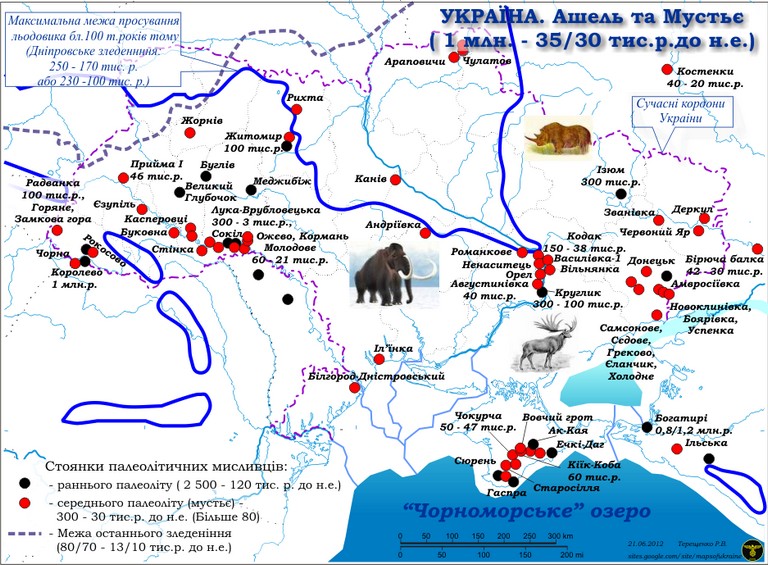
На території України нижній палеоліт знаходить своє відображення в багатошаровій пам’ятці Королеве (на Закарпатті) – найдавнішій для всієї Східної Європи, де археологічний горизонт (ашель, мустьє, початок пізнього палеоліту) датується приблизно 1 мільйоном років тому. Інші важливі місця – це знахідки в Гаспрі, Ечкі-Даг у Криму, Непоротове на Буковині та Меджибіж на Поділлі.

Середній палеоліт (150–30 тис. років тому)

Середній палеоліт включає пізню стадію ашелю (300–150 тис. років тому) та повністю охоплює мустьєрську епоху (150–30 тис. років тому). Це був час значних кліматичних коливань, спричинених наступом північного льодовика. Людина цього періоду, палеоантроп (Homo neanderthalensis), вперше пристосувалася до життя в суворих холодних умовах, вибираючи в якості житла природні укриття — печери та гроти. Цей період відзначається використанням левалуазьких та мікокських технологій обробки каменю, коли інструменти виготовлялися з відщепів, що отримували певну форму завдяки вторинній обробці. Типовими артефактами стали гостроконечники, скребла, ножі, різці та вироби з зубчастими виямками. Полювання, яке в цей час почало спеціалізуватися на окремих видах дичини, а разом із збиральництвом сформувало колективну систему господарювання, поступово перетворюючись із первісних груп у більш цілісні праобщини, у яких сформувалися перші статеві та харчові табу – передвісники екзогамних відносин.

Заселеність території України в середньому палеоліті мала пульсуючий характер через чергування наступів і відступів льодовика. Понад 200 пам’яток цього періоду зосереджені в основному навколо родовищ кам’яної сировини. Зокрема, в Криму виявлено численні стоянки (ущ Заскельне, Сари-Кая, Киїк-Коба, Пролом I і II, Шайтан-Коба, Кабазі II і V, Старосілля, Вовчий Грот та стоянку ГАБО), на Закарпатті – мустьєрські шари стоянок Королеве, Рокосове, Малий Раковець, у Подністров’ї – артефактні шари Молодового I і V, Кормань IV, Кетроси та Стінка, на Поділлі – знайдені пам’ятки у Великий Глибочок, Буглів, Прнятін та Єзупіль, на Волині – Житомирська стоянка, Рихта та Жорнів, у Надпоріжжі – місцевості Орел, Ненаситець, Скубова Балка, а також на Донбасі – Антонівка I і II, Курдюмівка, Званівка та Білокузьминівка.

Верхній палеоліт (35–10 тис. років тому)

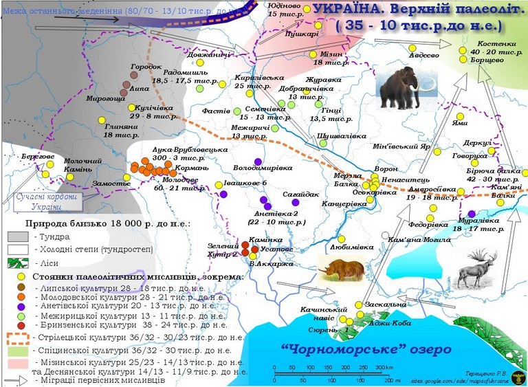
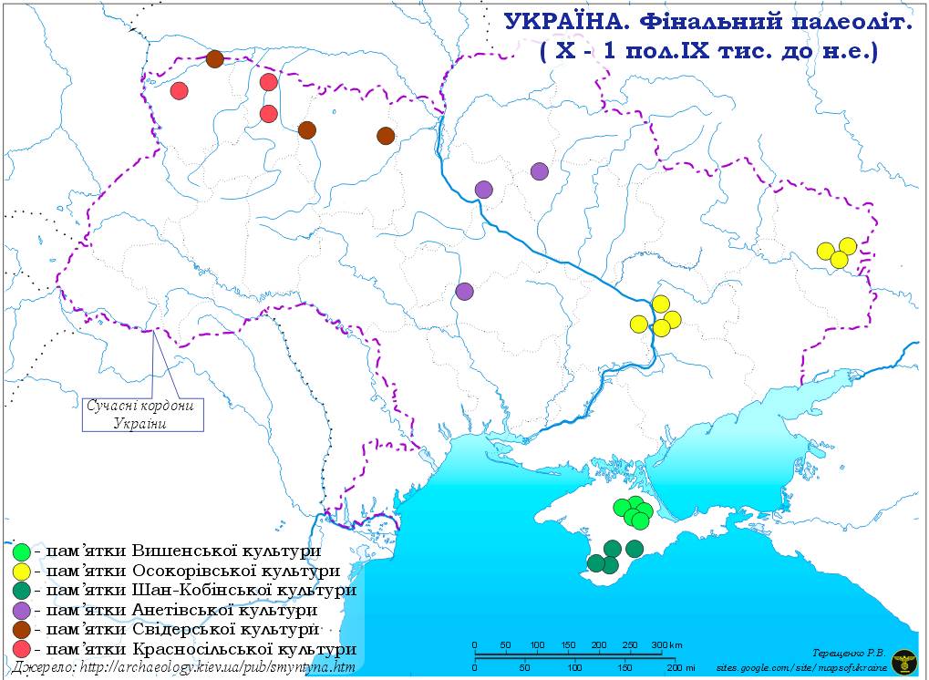
Верхній палеоліт – це період, коли на сцені з’явилася людина сучасного типу – кроманьйонець (Homo sapiens). Цей етап умовно поділяють на чотири стадії, кожна з яких відзначається специфічним культурним порядком. Ранній етап (35–24 тис. років тому) відзначається селетською та оріньякською кам’яною промисловістю, середній (24–17 тис. років тому) характеризується розвитком граветської культури, тоді як пізній етап (17–13 тис. років тому) відомий як епіграветська або мадленська культура. Окрему стадію становить фінальний палеоліт (13–10 тис. років тому), коли археологічні культури набули однорідності за набором інструментів.

У цьому періоді відбувається значний технологічний прорив: з’являється метод виробництва видовжених заготовок для інструментів — пластин. Кам’яні інструменти, такі як скребачки, різці, наконечники, тесла, проколки, свердла та ножі, характеризуються підвищеною спеціалізацією та стандартністю форми. Завдяки винайденню різця, кістка стає допоміжним матеріалом для виготовлення проколок, шил, руків’їв, пазових наконечників для списів, гарпунів та прикрас. Цей період також відзначається розквітом наскельного та переносного мистецтва, яке відображало найдавніші релігійні вірування – анімізм, магію та тотемізм.

Колективне полювання стало основою життєдіяльності людей верхнього палеоліту, досягши високої майстерності завдяки зональній спеціалізації на окремих видах стадних тварин, таких як мамонти, коні, бізони та північні олені. Первісні спільноти поступово переходили від напівкочового до осілого способу життя. Головною господарською одиницею ставала екзогамна родова община, що оселялася в довготривалих поселеннях, де в будівництві використовувалися, зокрема, кістки мамонтів та інших великих тварин. До кінця пізнього палеоліту спостерігалося розділення общин на парні сім’ї.

На території України верхній палеоліт представлений майже 900 пам’ятками. Селетська культура, з її пласкими двобічно обробленими наконечниками, знаходить відображення в стоянках, таких як Молодове V (шари 9 і 10), Міра, Буран-Кая III, Вись та Іллінка. Оріньякський період, позначений характерними нуклеоподібними скребачками, представлений стоянками Зелений Хутір, Сюрень I, Анетівка I, Сагайдак, Муралівка, Золотівка та Ворона III. Граветська культура, що відзначається виготовленням інструментів з великих видовжених пластин, пов’язана зі стоянками Молодове I і V, Кормань IV, Оселівка II, Вороновиця I, Королеве II та Троянове. Епіграветська культура, з її типовими мікровістрями з притупленими краями, представлена великою кількістю пам’яток як у північних регіонах (Межиріч, Мізин, Добранічівка, Гінці, Кирилівська стоянка, Фастівська, Бармаки, Семенівка), так і у південних (Амвросіївка, Велика Акаржа, Анетівка II).

Мезоліт та середньокам’яна доба України

Мезолі́т України, або середньокам’яна доба, охоплює період приблизно від 9 до 6/5 тисячоліть до нашої ери – епоху, яка настала після останнього, Вюрмського (Валдайського) льодовикового періоду.

Цей період характеризується як кульмінаційна стадія мисливського господарства, коли спостерігається його остаточна криза.

Зміни в природному середовищі, трансформації в господарській діяльності та зростання самостійності особистості в громаді спричинили широкомасштабні переселення населення та суттєві етнокультурні зрушення на карті України та Європи саме протягом середньокам’яної доби.

На території України цього періоду виділяють 10 окремих археологічних культур.

Сьогодні на українській землі знайдено близько 600 об’єктів – від короткочасних стоянок і тривалих поселень до поховальних комплексів та декількох церковних могильників, що свідчать про багатство та різноманіття життя давніх людей цієї епохи.

Рання середньокам’яна доба України

Для цього періоду в Україні зафіксовано понад десять різновидів археологічних пам’яток.

На південному степовому азово-чорноморському культурному краю домінували мікролітичні культурні типи, серед яких:

  • Шан-кобинська культура, що належить до гірсько-кримського регіону;

  • Осокорівсько-роральський тип, який зберігся у Подніпров’ї та на Донбасі;

  • Пам’ятки Білолісся, що знайдені у північно-західному Надчорномор’ї;

  • А також артефакти, пов’язані із культурним типом Сюрень-2 у Криму.

На північному полісько-лісостеповому культурному краю та в середньодністровській культурній зоні, що розташована на північ від азово-чорноморського регіону, виявлено вироби з мікро- та макролітичної обробки. До них належать:

  • Пам’ятки нобельського типу, поширені на Волині;

  • Зразки смячкинського типу, знайдені в Подесінні;

  • Елементи Міньївського Яру, що асоціюються із Сіверськодонеччиною;

  • А також пам’ятки оселівського типу, характерні для Середнього Поддністров’я та Передкарпаття.

Пізня середньокам’яна доба України

У пізньому періоді середньокам’яної доби на території України виділено понад десять археологічних культур і культурних типів пам’яток.

У межах азово-чорноморського мікролітичного культурного краю зустрічаються:

  • Мурзак-кобинський тип, що поширений у гірському Криму;

  • Гребениківська культура, характерна для Північного Надчорномор’я;

  • Кукрецька культура, яка виявляється у Криму, Степовому Поозів’ї та Надчорномор’ї;

  • Пам’ятки моспинського типу, зокрема в пінічно-східному Поозів’ї;

  • І знахідки ненаситецького типу, виявлені у Надпоріжжі.

У північному полісько-лісостеповому культурному краю домінували такі археологічні комплекси:

  • Кудлаївська культура;

  • Дніпро-прип’ятська культура;

  • Піщанорівська культура, яку можна зустріти на Подесінні, в Київському Подніпров’ї та на Волині;

  • Донецька культура, поширена в Сіверодонеччині;

  • А також народицька культура Волині, що, започаткована в ранню середньокам’яну добу, продовжувала існувати в пізньому її періоді.

Цей археологічний спектр надає нам унікальне уявлення про різноманіття первісних культур, які колись формували обличчя території сучасної України.

Obolonskyi Island

Obolonskyi Island is a small yet picturesque island on the Dnipro River within the city limits of Kyiv, located nearby and parallel to the Obolonska Embankment. For a long time, it remained a wild green area, popular among anglers, nature lovers, and those seeking informal recreation. The island lacked infrastructure, making it a haven for those looking to escape the noise of the city.

In 2024, the island was connected to Natalka Park by two pedestrian bridges. On the island itself, bike paths, beaches, sports areas, as well as cycling and running tracks were built.

вид на Північний міст

Trukhaniv Island

Trukhaniv Island is an island on the Dnipro River, located opposite the central part of Kyiv, between the main channel of the Dnipro to the west and one of the arms of the Desna river’s mouth—Chortoryi—to the east. Its area is about 450 hectares. Today, the island serves as a popular recreational zone featuring numerous beaches, water stations, sports facilities, restaurants, and holiday homes, and it is well-landscaped and connected to the right bank by the Pivnichny and Parkovyi pedestrian bridges.

острів Труханів і Тризуб

During the times of Kievan Rus, the settlement of “Olzhychi” was located on the island’s territory and belonged to Princess Olga.

тут був бобер

Origin of the Name

Researchers believe that the name “Trukhaniv Island” may originate from the name of the Kipchak (Polovtsian) Khan Tugorkan. According to legends, in the late 11th century, this area housed the residence of his daughter, who was married to Kyiv’s Prince Sviatopolk.

Landscape and Natural Conditions

The modern landscape of Trukhaniv Island is shaped by the last glaciation and the flow of the Desna and Dnipro rivers. The island is situated in the Desna Delta, where the river surrounds it on two sides. The territory features diverse natural zones, including dense forests, open spaces, and floodplain areas that change periodically due to seasonal flooding.

This varied terrain creates favorable conditions for a rich diversity of flora and fauna, including species under protection. Among the island’s wildlife are roe deer, red deer, hares, moose, and beavers.

вид на північну частину острова
вид з Труханового острову на південь, Київ
простори острова

Muromec park

Protected Natural Area

Trukhaniv Island is a conservation area where natural landscapes and habitats of wild animals, plants, and insects have been preserved. It is a popular destination among Kyiv’s cyclists for weekend rides. The northern part of the island remains a wild natural zone with dirt trails, while the southern section, beyond the Pivnichnyi (Northern) Bridge, features a designated cycling path. This route connects to Kyiv’s city center, leading to Khreshchatyk via the Parkovy Pedestrian Bridge.

Tryzub Island

Tryzub Island is a small, uninhabited island located near Trukhaniv Island. It is part of the Desna Delta and is surrounded by the Chortoryi branch of the river. The island is covered with dense vegetation and serves as a natural habitat for birds and other wildlife. It remains largely untouched by human activity, making it an important ecological area within Kyiv’s urban landscape.

Its shape resembles the symbol of Ukrainian statehood. The route around it is popular for kayaking and stand-up paddleboarding (SUP).

X-Park Sports Village

X-Park is a modern recreational complex built on the natural resources of Trukhaniv Island.

Here, you can find a cableway for wakeboarding, kayak and SUP rentals, as well as bike rentals. Visitors can also stay overnight, relax in a sauna in the evening, and take a swim in the Dnipro or Desenka rivers. Organized one-day trips around Trukhaniv Island and its surroundings also start from here.

вид з острова на Північний і Подільський мости, Київ, спортивне містечко Х-парк

Bicycle rental near Muromec Park and an island map for cyclists from

https://velokratia.com.ua/routes/park-muromec/


Samar

The city of Samar has a rich history dating back to the Yamna culture (4th–3rd millennium BCE). Archaeological research indicates the existence of settlements in the Prysamarya region since those ancient times.

During the Cossack era, Samara played an important role. The town of Samara was first mentioned in a charter by Polish King Stephen Báthory in 1576. In 1688, following the First Crimean Campaign, the Russian government built the Bohorodytska Fortress on the site of the old Cossack settlement of Stara Samara.

Holy Trinity Cathedral

One of Samara’s most significant architectural landmarks is the Holy Trinity Cathedral. This wooden church, built without a single nail, is the largest wooden church in Ukraine. The cathedral impresses with its unique architecture and serves as an important spiritual center of the city.

Samara River

The city is located on the Samara River, a left tributary of the Dnipro. The river originates on the western slopes of the Donets Ridge and flows through the Donetsk, Kharkiv, and Dnipropetrovsk regions. Samara is known for its natural wealth, particularly the Samara Forest and wetlands, making it an important ecological zone in the region.

The name “Samara” translates from Turkic as “virgin land, steppe.” Along its banks and in the wetlands, Cossack settlements once thrived. With the construction of the Dnipro Hydroelectric Station (DniproHES), the water level rose, forming the Samara Bay at its mouth.

Самара
гирло Самари

Husyntsi

Husyntsi: The Lost Village at the Bottom of the Dnipro

When the waters of the Kaniv Reservoir rose in 1971, they swallowed not only the streets, houses, and churches – they concealed an entire history. The village of Husyntsi, which had thrived on the left bank of the Dnipro for over two centuries, disappeared beneath the waves, leaving behind only a tract of land and the memories of its former residents.

The highest points formed several islands. On one of them stands the church, while the other—Lysa Hora—is where the main witches’ sabbaths of the entire Dnipro region take place (beginning at sunset on the first night of each full moon).

Лиса гора
вид з Лисої гори на церкву

Today, as the water level drops, remnants of the past occasionally emerge from beneath the surface: fragments of buildings, the foundations of the old church, and even bricks that once formed village homes.

A Crossroads of Trade

In the 18th century, Husyntsi was a small hamlet along a busy trade route. Merchants, soldiers, and travelers stopped here to rest. As the village became part of the Kyiv Vicegerency, it gradually expanded into a full-fledged settlement. By the 19th century, it had a school, an Orthodox church, and a monastic skete with a hospital and a mill.

The villagers practiced a unique craft—woven wickerwork. They didn’t just make baskets but also chairs, tables, and even cradles. Perhaps it was their fishing trade and handcrafted goods that helped the village survive the worst of the 1932–33 famine.

The Final Years Before Submersion

By the mid-20th century, Husyntsi was a thriving village with over a thousand residents. It became a film set, and a military base on its outskirts served as a training ground for soldiers. However, the decision to construct the Kaniv Reservoir sealed the village’s fate. Families dismantled their homes, salvaging what they could, and moved away. Only the church remained standing until the rising waters finally consumed its walls.

фотографії до затоплення села

Today, the Husyntsi tract serves as a reminder of how grand-scale projects reshape landscapes and destinies. The small islands emerging from the water are the last traces of a village that once lived a quiet yet vibrant life.

Yet, its memory endures—in the hearts of the elders, in faded photographs, and in the ancient church’s weathered stone walls, which miraculously survived.

Only three buildings remain from the village—the forester’s house, the school, and the church.

Visitors can stay overnight in the forester’s house.

будиночок лісника

The Church That Did Not Drown

The only structure that survived the flooding was the Pokrovska Church. Built in 1822 with the funds of local Cossacks and villagers, the temple was an architectural masterpiece. Its massive walls, elegant dome, and intricate details made it a striking example of sacred architecture.

After the flooding, the church was left stranded in the middle of the water—damaged but not destroyed. For years, it stood alone among the waves, like a ghost from the past. Some parts of the structure gradually crumbled, yet its core remained intact, defying time and nature.

Current State

In the early 2010s, efforts were made to restore the church. It was lifted with jacks, and a small artificial island was created around it, connected to the mainland by a wooden footbridge.

Unfortunately, during the restoration, the original frescoes were painted over, and the historic dome was replaced with a plastic one topped with a Chinese-made cross—changes that saddened historians and preservationists.

Today, visitors can reach the church via the footbridge from the left bank or by boat or kayak from Rzhyshchiv.

Dzharylhach

The continuation of Tendry is the island of Dzharylhach.
In ancient times, events described in Greek mythology took place here, and the islands were collectively known as Achilles’ Race.
One can set off on a long sea journey from Tendry along the celebrated route of Achilles and Iphigenia, though cycling there is challenging due to the sand.
Alternatively, you can reach closer to Dzharylhach from Kinburska Kosa, heading towards Lazurne or Skadovsk, where kayak rentals are available.
Indeed, a journey by kayak is the best way to uncover the magic of this enchanting corner!
Джарилгач

Achilles’ Race—this is what the ancient Greeks and the inhabitants of Olbia called the Tendrivska Spit, which connects with the island of Dzharylhach by a shoreline, forming something like a peninsula.
Ахілесів біг

In Dionysius Periegetes (2nd century AD), there is a legend in which Achilles, upon meeting Iphigenia, decided to take her as his wife.
However, as a priestess, she had taken a vow never to marry and thus could not accept Achilles’ proposal.
Madly in love, Achilles resolved to take Iphigenia by force. He chased after his beloved, but she preferred to throw herself into the sea rather than betray her patroness.

Artemis came to her devotee’s aid. As Iphigenia leaped into the sea, the goddess began scattering sand in front of her.
Achilles ran for a long time after the swift-footed Iphigenia, but he never caught up with her—his feet sank into the sand, exhaustion overcame him, and he finally abandoned the pursuit.

Thus, according to Greek belief, a sandspit more than a hundred kilometers long formed in the sea, which they named Achilles’ Course or Achilles’ Race.


Dzharylhach: The Pearl of the Black Sea

The island of Dzharylhach, located in the Karkinit Bay of the Black Sea, is the largest island in Ukraine and in the entire Black Sea.
It covers an area of 56 square kilometers, with a total length of 42 km, of which the land portion extends for 23 km.
The island has an elongated shape stretching from west to east. On its western side, it transitions into a long sandy spit, separated from the mainland by a narrow strait that sometimes dries up, temporarily turning Dzharylhach into a peninsula.

Relief and Geography

Dzharylhach features a flat terrain with numerous estuarine lakes, numbering around 200. Most of these lakes are saline, while a few are freshwater, with sizes reaching up to 150 meters in length and 15 meters in width. The total water surface area is approximately 9.49 km², making up 17% of the island’s territory.

The water temperature in summer reaches about 23°C, while in winter, it drops to around 2°C and rarely freezes. The salinity level varies between 16-18‰.

Tides in the Black Sea are minimal, with an amplitude of less than 8 cm. However, during storms, waves can wash over the spit, temporarily flooding the island’s coastal areas.

Flora

The vegetation of Dzharylhach includes steppe, meadow, wetland, and salt marsh species, as well as higher aquatic plants. A significant portion of the island is covered with artificially planted trees and shrubs. More than 20 plant species found on the island are listed in the Red Book of Ukraine.

Fauna

The wildlife of Dzharylhach is remarkably diverse. The island is home to acclimatized species such as the red deer, European fallow deer, and mouflon. Additionally, wild boars, foxes, and hares can be found here.

Migratory birds, including swans, ducks, geese, terns, sandpipers, glossy ibises, herons, and pelicans, use the island as a resting and nesting site.

Marine Life Around Dzharylhach

The waters surrounding the island are home to approximately 80 species of fish, including rays, flounder, red mullet, anchovy, Black Sea herring, sprat, and mullet. The local gobies are particularly famous for their excellent taste. Additionally, the area is inhabited by the spiny dogfish (katran), the only species of shark found in the Black Sea.

Shrimp and Other Marine Inhabitants

Dzharylhach Bay is teeming with marine life. The shallow coastal waters are home to over ten species of crabs, including the grass crab, stone crab, marble crab, and swimming crab. Among mollusks, the Black Sea mussel is the most widespread. Shrimp are also abundant in the area.

Insects

June is the peak season for mosquitoes on Dzharylhach. To ensure a comfortable stay, it’s essential to bring mosquito repellent and a tent with a mesh screen.

богомол
Dzha Lighthouse

Lighthouse and Freshwater Sources

One of the island’s most remarkable landmarks is the old lighthouse, built in 1902. It stands near the shore, and just a few dozen meters away is the new lighthouse, constructed in 1997. The old lighthouse is particularly captivating due to its historical charm and the presence of a freshwater spring—one of only two on the island.

The second freshwater source is located in an area known as “Monakh” (The Monk).

Kitesurfing in Dzharylhach Bay

Dzharylhach Bay, with its shallow waters and favorable wind conditions, is an ideal location for kitesurfing. The combination of warm waters, vast sandy beaches, and the absence of large crowds makes this spot particularly attractive for water sports enthusiasts.

Dzharylhach National Nature Park

Since 2009, the island has been part of the Dzharylhach National Nature Park. The park’s mission is to protect the natural heritage of the area, covering 10,000 hectares of land along with 2,469 hectares of the bay’s waters.

Dzharylhach Island is a truly unique place where nature has preserved its untouched beauty. Its rich flora and fauna, along with its picturesque landscapes, make it a hidden gem of the Black Sea.

Berezan island

Berezan Island is located in the northwestern part of the Black Sea, at the entrance to the Dnipro-Buh estuary, approximately 2 km from the village of Rybakivka in Mykolaiv Oblast and 12.8 km southwest of the city of Ochakiv. This makes it an interesting destination for kayaking, or visitors can opt for a guided tour by boat or sailboat.

The island is about 800 meters, with a width ranging from 200 to 400 meters, and covers an area of approximately 23.6 hectares. Its elevation reaches up to 20 meters above sea level. The island’s shores are subject to abrasion, leading to a gradual reduction in its size. The vegetation is mainly represented by xerophytic grasses and shrubs.

Historical Significance and Archaeological Research

Berezan is known for its rich history dating back to ancient times. In the 7th–6th centuries BCE, the ancient Greek settlement of Borysthenida existed here, considered the oldest Greek polis in the Northern Black Sea region. Archaeological excavations, ongoing for over a century, have uncovered remnants of dwellings, ceramics, and other artifacts that attest to the settlement’s active life. Among the findings are semi-dugouts and multi-room stone houses from the Hellenistic period, painted Ionian pottery, coins minted in Olbia, as well as Roman-period artifacts, including red-glazed ceramics and inscribed slabs.

In the Middle Ages, the island was known as Buyan and is mentioned in various historical sources. During the 14th–15th centuries, the island’s territory was under the control of the Grand Duchy of Lithuania and the Kingdom of Poland, and later, the Crimean Khanate. There was no permanent population on the island during this period.

In 1905, the Berezan Runestone—a Varangian runestone from the 11th century—was discovered on the island. It bears the inscription: “Grani made this mound in memory of Karl, his comrade.” This artifact confirms the presence of Varangians on the island and their interactions with the local population.

Monument to Lieutenant Schmidt

A monument to Lieutenant Pyotr Schmidt, one of the leaders of the 1905 Sevastopol Uprising, stands on the island. As a Tsarist officer, he led a rebellion demanding greater rights. After the uprising was suppressed, he was executed on the island. During the Communist era, Schmidt was turned into a revolutionary icon, and a monument was erected at the site of his execution.

Current State and Preservation

Today, Berezan Island is uninhabited but attracts tourists and researchers with its historical heritage and picturesque landscapes. It is part of the National Historical and Archaeological Reserve “Olbia”, which helps preserve and study its cultural and natural values.

Berezan Island remains a unique site where natural beauty intertwines with a rich, multi-layered history, making it an important object for scientific research and the preservation of Ukraine’s cultural and historical heritage.

Tendra island

From the finish of the cycling route on Kinburn Spit, on a clear day, a thin strip of land is barely visible on the horizon amid the endless sea. This is Tendra. You can reach the island by kayak in half a day, but to better explore it, it’s best to plan a two-day sea journey.

Tendra Island is a sandy spit that separates the Yagorlytska Bay from the Black Sea. Its formation began around 8-10 thousand years ago as a result of sand deposition by sea currents and wind activity. Geological studies indicate that this area was once part of the mainland, but gradually became separated due to the rising sea levels after the Ice Age.

Historical Mentions
The term “Achilles’ Run” was used by ancient Greeks and the inhabitants of Olbia to refer to the Tendra Spit, which connects with the island of Dzharylgach via the coastline, forming what seems like a peninsula.

In Dionysius Periegetes’ (2nd century AD) writings, there is a legend in which Achilles, upon meeting Iphigenia, decided to take her as his wife. However, the priestess had taken a vow of chastity and could not agree to marry him. Madly in love, Achilles plotted to take Iphigenia by force. He chased after his beloved, who chose to leap into the sea rather than betray her mistress. Artemis helped her favorite, and when Iphigenia jumped into the sea, Artemis began sprinkling sand before her. Achilles chased after the swift Iphigenia for a long time but never caught up with her, as his feet sank into the sand, and he grew tired, eventually abandoning his pursuit. According to the Greeks, this is how the spit, more than a hundred kilometers long, was formed in the sea, which they called Achilles’ Racecourse, or Achilles’ Run.

Ancient Greek artifacts have been found here, confirming the island’s use in ancient times. In the medieval period, Tendra served as a stopover for sailors and Cossack ships.

Nature Reserve

The island is part of the Black Sea Biosphere Reserve and is protected as a territory with unique natural complexes. Its ecosystems include sandy dunes, saline meadows, and steppe areas, creating a special environment for rare plants and animals.

Flora

Tendra Island is home to over 250 plant species, many of which are rare or listed in the Red Book of Ukraine. Notable representatives include:

  • Taliyev’s Sandwort (Arenaria talievii) – an endemic species of the Black Sea region.

  • Buzuk’s Carnation (Dianthus hypanicus) – a rare steppe species.

  • Dnieper Feathergrass (Stipa borysthenica) – adapted to sandy soils.

  • Liechtenstein’s Grasses (Cynodon dactylon var. lichtensteinii) – a salt-tolerant plant capable of withstanding soil salinity.

  • Tatar Sea Kale (Crambe tataria) – a steppe plant found on dune sands.

Fauna

The island is home to many animal species, including those listed in the Red Book of Ukraine.

  • Wild Horses (Tarpans) – Semi-wild horses inhabit the island. These are descendants of domestic breeds that were once released into the wild. They are well-adapted to the local climate and feed on steppe grasses.

  • Dolphins – In the coastal waters of Tendra Island, three species of dolphins are frequently encountered:

    • Bottlenose Dolphin (Tursiops truncatus)

    • Common Dolphin (Delphinus delphis)

    • Harbour Porpoise (Phocoena phocoena)

  • Karakurt (Latrodectus tredecimguttatus) – one of the most dangerous spiders in Europe. Its venom is more potent than that of a rattlesnake, although it is usually not fatal to humans.

  • Birds – Among the local inhabitants are the pink pelicans (Pelecanus onocrotalus), white-tailed eagles (Haliaeetus albicilla), waders, and many other waterfowl that nest on the island.
    Insects – Among the rare species are the Swallowtail butterfly (Papilio machaon), Hercules beetle (Dynastes hercules), and carpenter bee (Xylocopa valga).

    Tendra Lighthouse

    Tendra Lighthouse is one of the oldest lighthouses on the Black Sea coast, holding strategic importance for maritime navigation. It was built in 1827 and has remained unchanged since then, preserving its original appearance – a white, round stone tower, 30 meters tall, with two black horizontal stripes.

маяк на Тендрі

Initially, the lighthouse operated with oil lamps, which were later replaced by gas lamps, and now electric lanterns with automatic control are used. Thanks to its light, ships can safely pass by Tendra even at night.

The island has no natural sources of fresh water, except for the well near the lighthouse – don’t forget to collect water!

Relief and Dunes

The island has a flat relief, shaped by the influence of sea currents and wind erosion. The surface is primarily composed of sand dunes, with heights reaching up to 5-7 meters. Some dunes are stabilized by vegetation, preventing them from eroding, while others remain mobile, changing shape under the influence of the wind. Along the southern coast, coastal ridges formed by storm waves can be found. In the center of the island, there are low-lying areas – salt marshes, which are periodically flooded by seawater.

типовий пейзаж острова
напівпустеля

Current State

Today, Tendra is a protected area with restricted access. This helps maintain the natural balance and conserve the rare species that inhabit the island. It also remains an important site for scientific research, particularly in the fields of biology and ecology.

Facebook
Twitter
YouTube
Instagram